When we left Bedini Bugyal (11,155 feet) for our onward journey to Bhagwabasa (14,029 feet), we were very excited. There were two reasons behind that. First, there was a thrill of trekking at such altitude on the Himalayas. Second, After reaching Bhagwabasa in the afternoon, we were supposed to have the first glimpse of Roopkund Lake, to which we were travelling so far from Delhi. It was an incredible camping experience in the previous night at Bedini. The golden rays of setting sun over the snow-clad peaks, star-filled clear sky in the night, white peaks peeping out from the clouds and then the beauty of the Chaukhambha Peak in the morning, all were quite magnificent at Bedini.
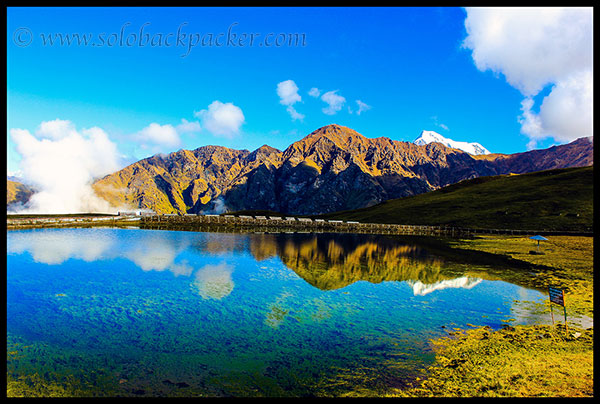
After all those visual treats, when we reached to Bedini Kund, it was again a magical scene. A spectacular canvass filled with the most beautiful colors of the nature was waiting for us at Bedini Kund.
We spent some time at Bedini Kund and moved further to reach on the trail, that is visible at the hill behind Bedini and goes towards Bhagwabasa. We moved towards a gradual slope on the hill to reach on that trail, but suddenly my mind was changed and I moved directly towards the trail through the steep slope. Kaptan (Captain) Sahab and Tanvir Sir followed me. Later, we realized that we made a big mistake. That climb was very steep and we were completely exhausted by the time we reached on the trail. On the other side, Sanjeev was happily moving on the gradual slope with our guide.
After controlling our breath at the trail, we looked around. What a magnificent view it was! Bedini Bugyal, Bedini Kund, White Clouds, Beautiful Valleys, everything hypnotized us for the moment. We forgot all our tiredness and enjoyed those moments of life-time.
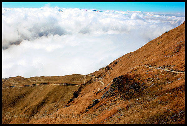
The trail to Bhagwabasa is generally moved along an mountain edge, but there is nothing to be scare on this trail. It is not like a narrow path with high mountains on one side and steep valley at another side. The slope of the mountains along the trail is generally gradual, so it doesn’t look scary. But still deviating from the path can create a trouble, specially between Pathar Nachauni and Kalu Vinayak.
Trekking from Bedini to Ghora Lotani was very easy. Ghora Lotani is about 2.0 kms from Bedini. It is named so, because the horses on this trek route don’t proceed beyond this point and they are expected to return (Ghora: Horses, Lotani: Return) from here. It also has a small camping ground, but nobody camps here generally. Water facility is not available here. But if you really want to camp here, then you can descend down to the green meadow after Ghora Lotani, which is a perfect camping site like Bedini. I am not sure of drinking water availability in that meadow.
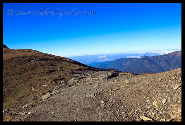
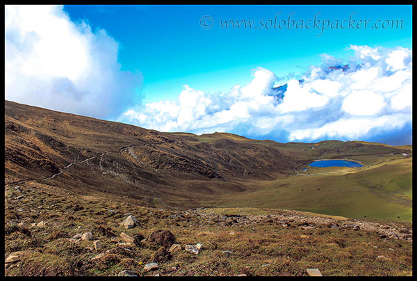
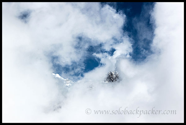
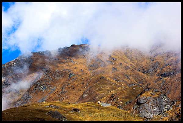
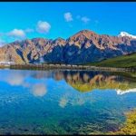
After passing Ghora Lotani, we reached to the other edge of the mountain. On the one side of Ghora Lotani, Bedini Bugyal attracts us with its lush-green beauty and on the other side, white peaks of Trishul and Nanda Ghunti awestruck every onlookers. When we reached there, a large portion of the valley was covered with the clouds, so we were unable to see any peak. For the few moments, some clouds blew away by the air and we got the glimpses of Trishul and Kali Dak peak.
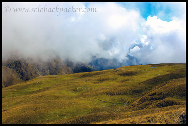
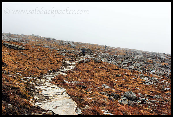
From Ghora Lotani to Pathar Nachauni (1.5 kms), it is again an easy trail with almost parallel route. An extensive area of alpine meadow is also present at this side of valley, however, it is much smaller than Bedini in size. Camping site at Pathar Nachauni is visible from much distance, and it consoled us that the next stop is nearby.
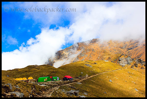
We reached at the camping site of Pathar Nachauni(12,770 feet) in two hours from Bedini. It is a small area along the trail. There is two fiber huts available by the forest department for the night stay. A running water pipe is also there for the drinking water.
There is a popular folklore associated with this name Pathar Nachauni or Pathar Nachauni. It is believed that once a King was there on a pilgrimage to Nanda Devi. He was traveling with a large troop and some royal dancers were also in that group. At the site of Pathar Nachauni, they started a party and the king was so much lost in their performance, that he finally cancelled the pilgrimage. The goddess of the mountains, Nanda Devi, became very angry and she turned all dancing girls in the statues of stone, hence the name Pathar Nachauni (Pather: Stone, Nachauni: Dancer). However, those statues do not exist anymore.
We were in the relax mood after reaching Pathar Nachauni easily, but the biggest hurdle was yet to start. Looking beyond Pathar Nachauni, we could easily see the steep trail on a mountain, where we had to move next in order to reach Kalu Vinayak (14,186 feet). This trail between Pathar Nachauni and Kalu Vinayak is considered as the most difficult stretch to cover, because of the steep climb, approx. 1420 feet climb in 2 kms distance. and if you plan to trek from Bedini to Roopkund in a single day, then you have to cover this stretch along-with another difficult stretch between Bhagwabasa and Roopkund. Climbing on two steep trails on a single day is really to punish your body, unless you are an experienced trekker. So people generally take a night halt at Bhagwabasa to trek further on the next day. Planning a night halt at Bhagwabasa also helps us to acclimatize with the high altitude properly.
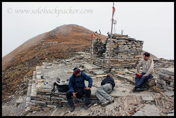
We had a target of three hours to climb on this steep trail to Kalu Vinayak. After lot of struggle between legs and heart, we reached there in 3 hours 15 minutes. I had a continuous headache, might be a sign of Altitude Mountain Sickness (AMS) or might be due to the lack of sufficient oxygen. I drank more water and took frequent rests on the route to manage my journey.
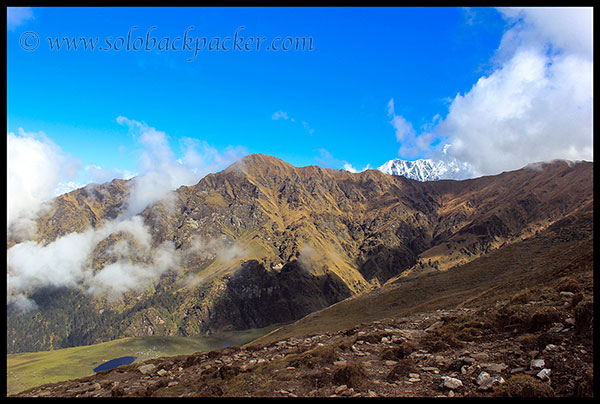
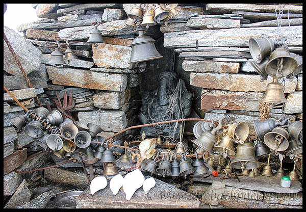
Kalu Vinayak has a small stone temple housing a black idol of The Lord Ganesha. Hence, the name Kalu Vinayak. The story behind Kalu Vinayak is that when Goddess Parvati was going to Kailash, she wished to take the bath in Roopkund Lake. She ordered her son Ganesha to stay at this place, Kalu Vinayak, to keep a watch, so that nobody could move towards the lake. Ganesha stood there as a standing guard, hence the name Kalu Vinayak (another name of Lord Ganesha). There is lot of ringing bells hanged around the temple, probably tied by the local devotees during Nanda Raj Jaat Yatra. Lot of conch shells (shankhs) are also kept there, but nobody blows them generally. This is also the first place from where one can see the crater of Roopkund Lake.
We were completely tired of hiking on this trail and our destination Bhagwabasa was still 1.5 kms away from that point. We wanted to take some rest before going further. So, we stopped there for 30 minutes.
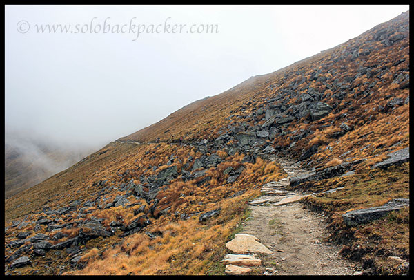
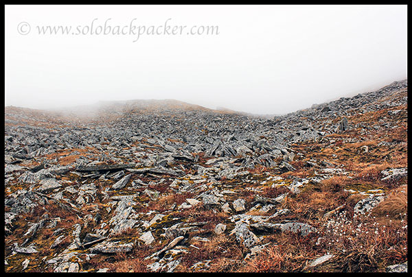
The trail from Kalu Vinayak to Bhagwabasa is quite easy because of the gradual descent. There are lot of stone blocks scattered around both sides of the path to make it a completely different landscape. In fact, Landscapes keep changing continuously on this trek route from Wan Village to Roopkund Lake. It starts with a thick forest of Oak trees after Wan Village. Then comes the beautiful grassland of Bedini. Alpine meadows of Bedini are left behind after Ghora Lotani and another grass land is there before Pathar Nachauni. After Pathar Nachauni, the vegetation gets thinner and thinner and after Kalu Vinayak, only big block of stones are visible at both side of the route.
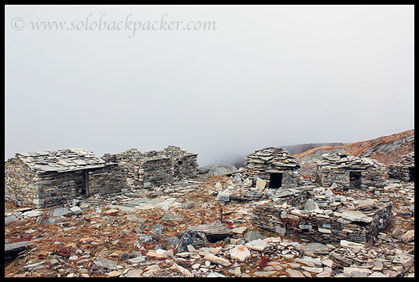
Just before the camping ground of Bhagwabasa, we saw some stone huts, smaller as well as bigger. Earlier, those huts were rented out to the trekkers for the night stay, but now most of them are destroyed and abandoned.
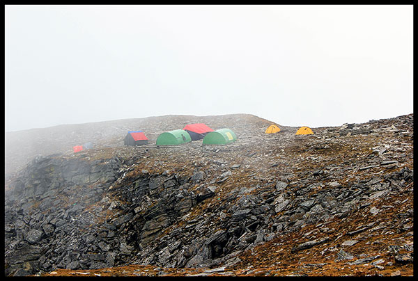
We reached to the camping ground of Bhagwabasa after a strenuous trek. It was our night halt for that day. As usual, we were again the only trekkers on that day at the camping ground. There was lot of clouds around the place, so nothing was visible. However, our guide told us that once the clouds would be disappeared, the white peaks of Nanda Ghunti, Trishul and Kali Dak would be clearly visible. Roopkund Lake is also visible from the camping site, as it is only 3 kms away from there.
We had a great evening at Bhagabasa. Next day, while returning from Roopkund, we again stopped there for two hours. It was a great experience to spend some moments at that place in the isolated world of the Himalayas. In the next post, I will share our camping experience at Bhagwabasa with some beautiful pictures of the Himalayan Peaks and surrounding valleys.
Related Posts
 Roopkund Trek 5: Night Camping at Bedini Bugyal
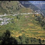 Roopkund Trek 10: Day Six and Final Trekking from Didna to Lohajung
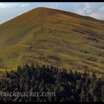 Roopkund Trek 9: Day Five Trekking From Pathar Nachauni to Didna Village via Ali Bugyal
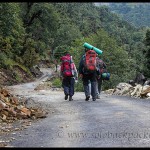 Roopkund Trek 3: Day One Trekking from Lohajung to Wan Village
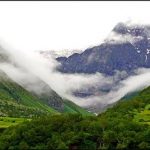 Valley of Flowers: A Paradise on the Earth
 Roopkund Trek Day Four: Bhagwabasa to Roopkund Lake and Junargali Pass
Are the tents, sleeping bags and other accessories for trekking available at Wan village?
Yes, you can arrange them at Wan Village. Also check their availability in Lohajung Village before proceeding to Wan.
We will go to roopkund at 10th October,but to see ur pic I am getting excited to be there as soon as possible
Nice photos…. Great info. Thaks. I am going this May on this trek.
hey when did you trek roopkund…we did it in april last year and it was unforgettable…the meadow is beautiful
Hi, we did it in October last year. It is indeed a beautiful trek.
Brilliant captures!
Thanks Niranjan !