Roopkund Lake: Roopkund is a small lake above the snowline of the Greater Himalayas. It is a very small swallow lake, maximum 2 meters in depth and generally remain under the snow for 8 months in a year. At the first glance, nothing special is here. I mean, a 2 meter deep lake, that too without water, is not worth visiting after 24 hours of road journey from Delhi and then a 3-days trek in the middle of a dense forest of Burans, a widespread meadow, some steep climbs on the hills, where you spend your night in a small tent. The nights are freezing cold, body easily become tired due to the thinner air and a single mistake can be fatal at this height. and we do all this for a 2 meters deep hole, that doesn’t even look like a lake.
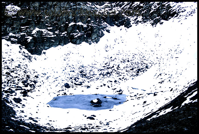
But, the beauty and charm of these snow-clad peaks, alpine meadows and dense forests attracts hundreds of trekkers every year to this place. Some of them come here to solve the riddle of bones, skulls and skeletons buried deeply under the snow in this lake, Some people come here to enjoy the green alpine meadows and some of them are mesmerized by the beauty of the heaven that lies above the cloud at 16000 feet. Roopkund Lake is also known as The Skeleton Lake. Hundreds of human bodies buried here. Nobody knows, how? Carbon Dating suggests that these skeletons buried here from almost hundred years when some people died in a fatal hailstorm. But the question remains same, why those hundreds of people came to such isolated place? Some believe they came here for religious purpose, other believe that they were here for commercial purpose. Some even believe that they belong to the army of a King and they came here for a political purpose. Whatever was the reason for their presence at this place, they never went back. They became an integral part of Mighty Himalayas and this place became the part of many mysteries of Himalayas. Today, Roopkund Trek is considered among the best treks in India. It is considered as a moderate trek on the scale of difficulty and it is really easy to complete this trek. But still, at these heights, you have to test your patience, discipline and your limits at each and every step.
Location: Located in a remote corner of Chamoli District of Uttarakhand State, it is a completely isolated place with no permanent human settlements in the vicinity, at the height of 4750 meters or 15800 feets approx (some reports says 5029 meters, 16500 feet approx). It is surrounded by snow-glaciers and situated near the base of two Himalayan peaks Trishul, and Nanda Gunti. Despite of its increasing popularity, it generally remains inaccessible for six months in a year because of its high altitude and continuous snow.
Best Time to Visit: May Last Week-June and September-October. Expect trekking on the snow in the beginning of May. In fact, sometimes you may not be able to reach Roopkund in the month of May also due to heavy snow. Avoid rainy season of July and August. Again September and October is a nice time to trek here. After October, it is generally not advisable to trek alone because of the extreme cold. After November, expect heavy snow in the area.
How to Reach? Roopkund is not connected to a motorable road all the way. It requires a trek for about 23 kms after the last motorable point, Wan village, to reach up to Roopkund Lake. So, there is basically two parts in this journey to Roopkund: Motorable Part and Trekking Part
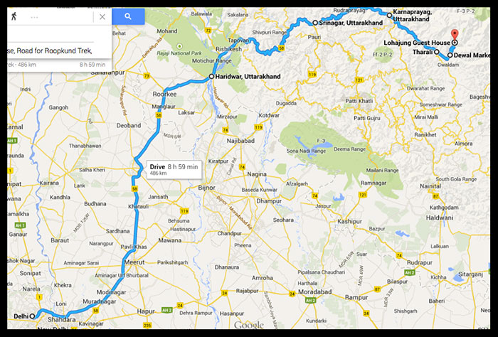
1. Motorable Part: Being in a remote area, it requires a lot of effort to reach here, unless traveling on a hired vehicle or a private car. From Delhi, a combination of train, buses and shared jeeps are required to reach at Wan Village after the journey of at least 24 hours. Distance wise, it is about 530 kms from Delhi via Haldwani, Almora and about 505 kms from Delhi via Rishikesh, Karnaprayag.
These two different routes have their own advantages and disadvantages:
(i) Via Haridwar: Delhi-Haridwar-Rishikesh-Sri Nagar-Karnaprayag-Tharali-Dewal-Lohajung-Wan Village (Total, 505 kms, not less than 20 hours in continuous journey)
This route is in better condition as it is the lifeline of Uttarakhand. It is the main route of famous Char Dham Yatra for Badrinath and Kedarnath (Gangotri and Yamunotri are at other side) and accessible throughout the year. Most parts of this route passes through the edge of mountains along the river valley of Alaknanda, thus providing amazing views of the river and its valley. The only disadvantage is the heavy landslides during the rainy season, that may resulted in the frequent blockage of the roads.
Delhi-Haridwar/Rishikesh: Haridwar is 220 kms away from Delhi and has a very good bus connectivity with Delhi. Trains are also available, but they are very few. From Maharana Pratap ISBT in Delhi, government buses are available at very frequent intervals (frequency approx. 30 minutes throughout the day). Some AC VOLVO buses also run between Delhi and Haridwar. It generally take 5-6 hours to reach Haridwar from Delhi. Rishikesh is further 20 kms away from Haridwar. Some trains and buses from Delhi also goes upto Rishikesh, but mostly terminate at Haridwar.
Badrinath/Rishikesh- Karnaprayag: For this portion, you can either catch a bus from Haridwar or from Rishikesh. Most buses start from Haridwar and move further via Rishikesh. If you catch a bus from Haridwar, you have a high probability to grab a good front seat. Prefer a window seat in the right hand side in the direction of the bus for the best views of the river valleys ahead.
Some buses also start from Rishikesh and if you are at Rishikesh bus stand, then you can also catch a bus originating from Dehradun, the state capital, that moves forward at your route. But you may not be able to get a preferred seat.
These buses operate at frequent intervals between Haridwar/Rishikesh to Karnaprayag starting from 4 AM to 11 AM. These buses are usually smaller than the normal buses in the size, because of hilly roads and basically operated by GMOU or Uttarakhand Roadways. All buses going to Joshimath/Badrinath from Haridwar or Rishikesh pass through the town of Karnaprayag. For this 195 kms journey from Haridwar to Karnaprayag expect to spend at least 8 hours in the bus with 30 minutes stop at Srinagar along-with some small stops en-route.
Karnaprayag is a big town on the confluence of Pindar River and Alaknanda River and considered as one of the panch prayag (five confluences) in Uttarakhand. After leaving the bus at Karnaprayag, move towards the road going to Gwaldam to catch another vehicle to Tharali, 45 kms away.
Tips: 1. GMOU bus office is just 100 meters before the Roadways bus stand in Haridwar, near Haridwar Railway Station on the same side of the roadways bus stand.
2. After 11 AM, a direct bus to Karnaprayag may not be available, so you can catch a bus to Srinagar and from there, another transport to Karnaprayag.
Karnaprayag- Tharali: Frequent shared jeeps are available from Karnaprayag to Tharali. Buses are infrequent. The driver of the shared jeep doesn’t move unless he get 10 passengers in the jeep. So, expect to wait 20-60 minutes at the stand only. It is about 2 hours journey from Karnaprayag to Tharali.
This small town is situated at the bank of Pindar River, that further merges in Alaknanda River at Karnaprayag. Sometimes these shared jeeps stop in beginning of the market at Tharali. In that case, walk for about one kilometer on the main road and cross the iron bridge on Pindar river. On the way, there are lot of signs of the biggest natural disaster of Uttarkhand that occurred in June 2013. Beyond Tharali, the effect of that disaster was very low. After crossing the river, walk for about 100 meters to the jeep stand to catch another shared jeep to Dewal, 13 kms away.
Tharali-Dewal: Dewal is the last descent town on this route. It is about 45 minutes journey from Tharali to Dewal. Shared jeep fare is INR 40. Try to shop all the necessary things, that you need during Roopkund trek from here only, as you may not be able to get those things at the relatively smaller market in Lohajung.
Dewal-Lohajung: Lohajung is generally considered as the base camp for Roopkund Trek, as most of the tourists start their trek from here only. It is about 17 kms away from Dewal and 1 hour journey (shared jeep fare INR 50) by the jeep. There is a small market in Lohajung, where you can shop other essentials for the trek. You can also rent some trekking equipments from the local shops in Lohajung.
Lohajung – Wan: Some people also goes beyond Lohajung to Wan village by a shared jeep. For this 15 kms journey, fare is 80 INR approx for a person. Wan village is another base camp to start this trek.
Note:
1. A Direct bus service is also availble from Rishikesh to Lohanjung, operated by Uttarakhand Roadways. It departs from Rishikesh at 04:00 AM and takes about 12-14 hours to reach Lohajung. This bus service is highly subjected to the weather conditions and road conditions in that area. The fare is approx. 400 INR.
2. Another bus operated by Uttarakhand Roadways is available from Rishikesh to Tharali. This bus starts from Dehradun at 05:00 AM and goes upto Bageshwar. It reaches Rishikesh at 06:30 AM and Tharali at 04:00 PM.
3. If possible and if available, always board a MAXI vehicle. It is slightly longer than Mahindra Bolero. Bolero is not comfortable for four people on the middle seat or four people on the front seat.
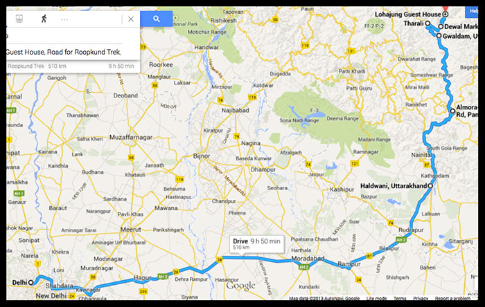
(ii) Via Haldwani: Delhi-Haldwani-Kathgodam-Almora-Gwaldam-Tharali-Dewal-Lohajung-Wan Village (Total, 529 kms, not less than 20 hours in continuous journey)
This route is also accessible throughout the year and not prone to the landslides generally. The beauty on this road is unparalleled as some of the most famous hill stations are located along this route. They include Nainital, Almora, Kausani, Baijnath and Gwaldam.
Delhi-Haldwani/Kathgodam: A train is the best mode of transport for this leg. There are mainly three trains (Shatabdi Express, Uttar Sampark Kranti Express and Ranikhet Express) available between Delhi and Haldwani. I always recommend Ranikhet Express as it starts from Delhi in the night at 10:30 PM and reaches Haldwani in the morning at 04:30 AM. Reaching Haldwani in the early morning is a good idea for onward journey. Kathgodam is the last rail-head on this section and 10 kms away from Haldwani. It is better to leave the train at Haldwani, rather than Kathgodam, because Haldwani is a bigger city and transports for onward journey can be arranged here in a better manner.
Haldwani-Gwaldam: After reaching Haldwani, the next aim is to reach Lohajung, either on the same day or by the next day. There is no direct bus/jeep runs between Haldwani and Lohajung, but you can book a reserve vehicle always from Haldwani to Lohajung.
To continue onwards journey from Haldwani, better to get a shared jeep to Gwaldam. Gwaldam is a small hill-station at the height of 1708 metres (5604 feet). This 174 kms journey from Haldwani to Gwaldam takes approx 6 hours. The fare for this shared jeep journey is INR 350 per person.
There are many options available on this route for the night stay. We went straight from Haldwani to Gwaldam on the first day, as our main aim was to reach Lohajung on the next day afternoon. Depending on your choice and availability of time, you may choose to stay at Almora, Kausani or anywhere else on this route. All are very famous hill-stations in this area.
Note: 1. When you board a shared jeep from Haldwani, the driver insists that he goes upto Gwaldam. But, very few (say only 2-3 jeeps) in a day, goes from Haldwani to Gwaldam. In reality, you have to board another jeep from Garur for Gwaldam. But you shouldn’t worry about it. Once you paid Rs.350 as the fare to Gwaldam, its your driver’s responsibility to arrange you an onwards transport from Garur to Gwaldam (25 kms). and they arrange it honestly. If you are unlucky like us, then you may land in the trap of some drivers, who are really irritating. The jeep driver will not move unless, the jeep gets full with its capacity of 10 passengers. It may take upto 2 hours as in our case at Haldwani. And our driver was very irritating, stopped jeep after every 2 kms to speak with someone. He even called people shopping on the local shops to board the jeep and kept waiting throughout the way till Garur. The journey from Haldwani to Garur, which was supposed to end in 5-6 hours, took 10 hours for us.
2. On the way, the drivers stop at a dhaba for the breakfast/lunch.
3. There are vehicles plying on this road in the night also, but you may not get a transport in the night beyond Almora if starting in the evening from Haldwani.
4. Two direct public buses run by Uttarakhand Roadways are also available between Haldwani and Gwaldam. First bus starts from Haldwani at 5 AM and goes upto Dewal. It is popularly known as Delhi-Dewal bus service. This bus basically starts from Delhi Maharana Pratap ISBT at 07:00 PM everyday. Second bus starts from Haldwani at 8 AM and goes upto Gwaldam.
Gwaldam-Tharali: There are frequent shared jeep available on this stretch. This 23 kms journey takes one hour and fare is 40 INR per person. Some private buses also operate on this stretch.
Tharali-Dewal-Lohajung-Wan: From Tharali to Wan village, you can proceed as explained in the above option (i).
Note: There is also a direct road available between Gwaldam and Dewal. But this road is not in very good codition, so generally no vehicle move on this road. However, if you can trek, Gwaldam to Dewal is approximately 8 kms easy trek, mostly descend through the hills.
Before starting of the trekking parts, be clear on these points:
Can I do it Solo? Yes, you can. Many people did the same and you can also. But, the problem is the food. Beyond Bedini Bugyal, there is no dhaba for food. So if you don’t have your own food, then you have to proceed from Bedini Bugyal to Roopkund and then again return to Bedini Bugyal on the same day.
Tour Operator or Own Effort? At least three tour operators are working in this area. Their tour packages vary from INR 8000 per person to INR 10000 per person. They arrange all the required equipments like tent, sleeping bag and also arrange mules, guides etc. Usually, there are 20-30 people in a group. So, in this case, you have to pack your backpack only and rest of the things will be arranged. But, we did it without any tour operator. We were four people in the group for this trek. We carried our own sleeping bags & tents and hired a mule. At the end of the trek, we spent only INR 4800 per person for this trek, that too included a night stay in Gwaldam and another night in Almora. Choice is yours only. If you wish to enjoy this trek on your own pace in a cost-effective manner, then do it on your own. But if you don’t wish to take much hassle of planning, then you should go to a tour operator.
Can I do it without guide? Yes. The trail is clearly visible and not confusing. In the peak seasons, there are many people on this treks. The funda is where there are two trails and you are not sure, wait for the help.
Mule or Porter? Whether you hire a porter or a mule, both charges are INR 400 per day. Mule can carry the luggage of three person at least, while porter can carry only one bag. So, if you are in the group, always hire a mule. But keep in mind, that beyond Bhagwabasa, mule doesn’t go. If you are trekking beyond Junargali to Ronti Saddle, then you have to hire a porter only.
I always recommend to hire a porter or a mule, if total weight of your backpack and day-pack exceeds beyond 10 kgs. We were in no mood to hire a porter, as it goes against the ethics of trekking in our opinion, but the first day trek from Lohajung to Wan made it clear that without hiring a mule, we were not able to trek for next five days. It depends on individual to individual, so be sure to enjoy your trek without worrying about the physical stress. One of our team-mate carried his backpack himself all the way and back.
Carrying Foods: Required or Not? Its an absolute requirement. You need energy to trek, so never ever try to skip a meal. If you are alone, you don’t have another choice except Bedini Bugyal- Roopkund- Bedini Bugyal trek in a same day, unless you have the cooking utensils and other essentials. If you are in a group, you can hire some cooking utensils, stoves and food items from Wan Village.
But the fact is, we also went without food and without any cooking equipment. Luckily, We were able to manage the meals somehow always, but you may not get that chance. I can’t disclose our food arrangements here.
Altitude Mountain Sickness (AMS): I only suggest one thing on this: Whenever you feel headache, extreme tiredness, breathing problems, wait for 10 minutes if you can and if problem still persists, just descend down to the lower altitude. No other compromises.
In our trek route, night halts were selected at varying altitudes, so that we could get proper acclimatization everyday. Perhaps, this was the reason that all four members (30 years, 30 Years, 45 Years and 51 Years old, all male) of our team completed this trek successfully.
Here is a brief review of the trekking part:
2. Trekking Part: There are mainly two villages to start this trek. One is Lohajung and other one Wan Village.
Route 1: Lohajung is basically the base camp for the trekking companies operating in this area. The typical tour programme looks like Lohajung- Didna Village- Ali Bugyal- Bedini Bugyal- Pathar Nachauni- Bhagwabasa- Roopkund- Junargali – Pathar Nachauni- Bedini Bugyal- Wan Village- Lohajung. But, we did it in reverse direction and climbed via Wan village and returned via Didna Village.
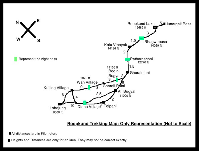
Route 2: This route again starts from Lohajung only, but goes like: Lohajung – Wan- Bedini Bugyal – Pathar Nachauni – Bhagwabasa – Roopkund – Junargali – Pathar Nachauni – Bedini Bugyal – Ali Bugyal – Didna Village – Kulling Village – Lohajung.
You can choose either of these routes. Both routes required almost the same level of hard work and equipped with the same level of facilities as they are same route in a single circuit, where you have choices to move either in clockwise or anti-clockwise in direction. Let us have a quick look on the trek route followed by us:
Day 1. Lohajung – Wan Village: 15 kms, 5 hrs
Night Stay: Wan Village
Difficulty Level: Easy. Lohajung is conncted to Wan village by a motorable road and 2-3 jeep services in a day are available between both villages. The fare for this 15 kms long journey is about INR 80 per person, if jeep capacity is full, otherwise approx. INR 500 for a reserved jeep. But, rather than hiring a jeep, we decided to trek for this part. It is generally a flat road between Lohajung and Wan Village without any significant climb or descent.
Wan is the last point where you can hire a porter, mule and trekking equipments. This is the last point to charge your camera and mobile batteries, because after this, there is no electricity until you returned back to Lohajung after 4 days. Wan is also the last point to take the bath, because beyond Wan, you may not be able to bath for next 5 days. Mobile connectivity (Airtel, Idea and Vodafone) is available at some points beyond this village.
Day 2. Wan-Bedini Bugyal: 11 kms, 6 hours
Night Stay: Bedini Bugyal
Difficulty Level : Moderate, expect 4-5 kms of steep climb through the dense forest. On the way, mobile connectivity is available in the vicinity of a point known as Garoli Patal.
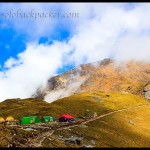
Facilities at Bedini Bugyal: Three fiber huts from the forest department, Camping Site, A Dhaba. No toilets, All open surrounding is your toilet, Use extreme corners for this purpose away from camping ground. Drinking water is available at the dhaba. A running water pipe is there, where you can bath, but water is very cold. You can buy a bucket of hot water from the dhaba by paying approx. Rs 30 per bucket. Snow peaks of Trishul, Chaukhambha, Neelkanth, Bandarpunch, Aadi Parvat, Nanada Gunti and Kali Dak is visible from Bedini Bugyal. Nice place for star gazing. No mobile networks.
Day 3. Bedini Bugyal- Pathar Nachauni – Kalu Vinayak – Bhagwabasa: 7-8 kms, 5 hours
Night Stay: Bhagwabasa
Difficulty Level : Initially, 3 kms easy ascend to Ghora Lotani. On a clear day, it is a nice view point for the snow peaks. Again 1.5 kms easy trail to Pathar Nachauni. From Pathar Nachauni, 2 kms very difficult climb to Kalu Vinayak and then 1.5 kms easy trail to Bhagwabasa.
Facilities:
Ghora Lotani: No Food, No Water, Camping Sites for few tents, but better to move ahead.
Pathar Nachauni: Food Not Available, Water Available. Two Forest Department Fiber Huts available. Camping ground available. Again a running water pipe. If you wish, you can bath. Earlier, there was a Dhaba, but now its not there. If you are lucky enough, you can get Mobile Networks just above the Camping Site. I was lucky with Vodafone network.
Bhagwabasa: No Food, No Water. Two Forest Department Fiber Huts available. Camping ground available.
Day 4. Bhagwabasa- Roopkund- Junargali- Bhawabusa- Pathar Nachauni: 11 kms, 2 hours to Roopkund, further 30 mins to Junargali and while returning back, 4 hours to Pathar Nachauni via Bhagwabasa and Kalu Vinayak.
Night Stay: Pathar Nachauni
Difficulty Level: 2 kms easy trail and then 1 km very difficult climb to Roopkund Lake. Junargali Pass is just above the Roopkund Lake. 30 minutes moderate, but risky climb through the snow.
Facilties: Water stream is available on the way to Roopkund.
At Roopkund: no shelter, no water, no food
Day 5. Patthar Nachauni- Bedini Bugyal Upper Ridge – Ali Bugyal – Didna Village: 12-14 kms, 6 hours
Night Stay: Didna Village
Difficulty Level: Easy. This is a very long trek on a single day, but its an easy one again. From Pathar Nachauni, easy descend to Bedini Bugyal. Don’t descend down to Bedini Kund or Camping ground. Just follow the ridge of the mountains and trail will take you to Ali Bugyal. From begining of Bedini Bugyal to the end of Ali Bugyal, its about 6 kms trail, mostly parallel. Near the end of Ali Bugyal, two trails are leading to Didna Village. Longer one goes via Tolpani, while shorter one leads through a dense forest of Burnas. If you proceed on the shorter steep descend, you can save only one hour. Mule owners generally don’t go on the shorter route as it is not convenient for the mules.
Facilities:
Ali Bugyal: No Food, No Water, No mobile networks
Tolpani: Water Available
Didna Village: 3-4 guest houese are available in the village. You can expect a basic accommodation, descend food, drinking water, toilet and bath. But, electricity is not available in the village. Mobile networks available.
Day 6. Didna- Kulling- Lohajung: 9-10 kms, 5 hours
Difficulty Level: Easy, Last day of trek. Steep descend to Neelganga for 2 kms and then steep climb to Kulling village for 2 kms. From Kulling, you can either trek to Lohajung or hire a jeep that may cost you INR 400 for 6 kms.
There is another trail going directly from Didna to Lohajung. First descend to Neel Ganga for 2 kms and then climb on the trail going to Lohajung. Its a steep climb for 6 kms and not advisable in my opinion.
Charges levied by Forest Department on the trek route: If you travel with a travel operator, then they will pay it directly to the representative of the forest department. But if you travel on your own, then you have to pay these charges. Strong chances are there that you may not be able to meet that representative. So, don’t search him, proceed on your route. He may cross your path during the return trek. In our case, when we send our mule owner to buy some breakfast from Bedini Bugyal during the return trek, he deliberately sent that forest guy to charge us. Whatever money he demands, just ask for the receipt. Typical charges are:
1. Pitching Your Tents at Camping Site: INR 100 per tent per night
2. Roopkund Trek Permit: INR 60 per person for full trek
3. Entry charges for guide: INR 20 per night (paid by the trekkers only)
4. Entry charges for mule: INR 25 per night (paid by the trekkers only)
5. Renting a fiber hut of forest department: INR 200 (for a hut, not per person and at least 7-8 people can be accommodated in a single hut). There is no advance booking system for these huts. No chance on the internet also. It is only available on first cum first basis unless there is some VIP trip. During the peak season, very less chances are there to get these huts.
6. Waste Recyciling Charges : INR 10 per camping site
7. Environmental Protection Charges: INR 20 per camping site
Points to Note:
1. While returning back on the last day of the trek, if you start early from Didna, you can reach Lohajung by 11:00 AM. But if you are lucky enough then only you can get a shared jeep to Dewal. If a tourist group arrives from Dewal to Lohajung at that time, then the chances are high to return back by that jeep. But its probability is very low. So, if you are unlucky to get a shared jeep from Lohajung, then only option is to hire a jeep to Dewal like we did and it cost us INR 800 in total.
2. Try to leave Dewal by 03:00 PM, otherwise you may stuck there for that night, if you are in no mood to hire a jeep again.
3. Again Try to leave Tharali by 05:00 PM, if you want to go beyond Gwaldam towards Kausani or Almora. Similar is the case if you wish to move towards Karnaprayag from Tharali.
4. Just remember, as the evening approaches, getting a shared public transport will be difficult and you have to rely on hired vehicles.
Facilities Avialble at Major Towns on The Way:
Srinagar: Many Hotels, Guest Houses and Restaurants, Large Market, Number of Banks (HDFC, PNB, SBI etc) and ATMs, All Mobile Networks (Major Operators Airtel, Vodafone, Idea, BSNL, Reliance)
Karna Prayag: Many Hotels, Guest Houses and Restaurants, Large Market, Major Public Sector Banks and ATMs, All Mobile Networks (Major Operators Airtel, Vodafone, Idea, BSNL, Reliance)
Haldwani: Many Hotels, Guest Houses and Restaurants, Large Market, Number of Banks (HDFC, Axis, PNB, SBI etc) and ATMs, All Mobile Networks (Major Operators Airtel, Vodafone, Idea, BSNL, Reliance)
Kathgodam: Relatively expensive Hotels, Guest Houses, Budget as well as high-end Restaurants, Small Market, SBI Bank and its ATM, All Mobile Networks (Major Operators Airtel, Vodafone, Idea, BSNL, Reliance)
Gwaldam: 3-4 Hotels (Decent and cheaper one is GMVN, at the higher-end and newly built is Nature’s Treat) and 2-3 small Restaurants, Medium Size Market, SBI Bank and its ATM, All Mobile Networks (Major Operators Airtel, Vodafone, Idea, BSNL, Reliance)
Tharali: 3-4 Guest Houses and 2-3 small Restaurants, Medium Size Market, SBI Bank and its ATM, All Mobile Networks (Major Operators Airtel, Vodafone, Idea, BSNL, Reliance)
Dewal: 3-4 Guest Houses and 2-3 small Restaurants, Medium Size Market, SBI Bank and its ATM (Last ATM on the way to Roopkund, may remain unserviceable), All Mobile Networks (Major Operators Airtel, Vodafone, Idea, BSNL, Reliance)
Lohajung: 2-3 Guest Houses and 2-3 small Restaurants, Small Market, No ATM, All Mobile Networks (Major Operators Airtel, Vodafone, Idea)
Wan Village: 2-3 Guest Houses and 2-3 small Restaurants, Very Small Market, No ATM, All Mobile Networks (Major Operators Airtel, Vodafone, Idea)
The Last Note: Like other popular destinations in the Himalayas, Roopkund Trek also suffers from the side-effects of over-commercialization. Serenity and tranquility of the trekking route is degrading day by day due the heavy influx of tourists. I only request you that be a responsible trekker, please don’t litter on the way, don’t do any activity that leads towards environmental degradation, so that beauty and charm of these mountains can attract the future generation also.
Related Posts
 Roopkund Trek 6: Day Three Trekking from Bedini Bugyal to Bhagwabasa
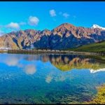 Roopkund Trek 5: Night Camping at Bedini Bugyal
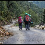 Roopkund Trek 3: Day One Trekking from Lohajung to Wan Village
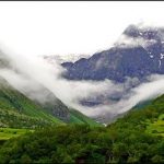 Valley of Flowers: A Paradise on the Earth
 Kedarnath Temple: Trekking from Gaurikund
 Gwaldam: A Beautiful Hill Station in Uttarakhand
Yo Man! I am also planning to trek to Roopkund and beyond.
—
Thanks for sharing your bol… It is very helpful. During which month of the year did you plan your trek… We are planning to trek uptil Bedini Bugyal and if weather/route permits, beyond that as well in the mid of April. Is it feasible.
Hi, we went there in the first week of October last year. You can comfortably go to Bedini in April..Beyond Bedini, there will be snow towards Roopkund. But, if you wish to try, then you can trek up to Roopkund also.
Very Well explained !!!!!
Very well described
Thanks Rupesh..Keep travelling 🙂
Hi,Solo Backpacker.
It’s Really a wonderful & Detail trek post i ever read regarding Roopkund trek.
this is Nayan,from Bangladesh…a novice trekker.i am planning to trek roopkund for last 1.5 years while i trekked Sandakphu in darjeeling backed in 2012.
would you plz,suggest me the easiest way to come lohajong from kolkata in a less time consuming way.
I do prefer..train journey as it’s cost effective.
your earliest response will be highly appreciate.
With Thanks,
Nayan Das
Hi Nayan, the best and efficient way to reach Lohajung from Kolkata by train is via Bareilly, Haldwani. Try to get a superfast express train from Kolkata to Bareilly. There are at least four superfast trains on this route. A train (Bagh Express) from Hawrah also goes to Haldwani, but it takes a lot of time. Check your preferred schedule at Indian Railways website. From Bareilly, you can get plenty of buses to Haldwani (98 kms away) at frequent intervals. From Haldwani, follow route Almora-Kausani-Gwaldam-Tharali-Dewal to Lohajung as described in this post. Expect to change many shared jeeps on this route.
Regards.
Thanks!!!
One more thing, i want to trek with my wife like sandakphu.So,is there any security issue? as i will not go through any commercial tour operator..rather own backpacking.
What u suggest.
With Regards,
NaYaN
Its perfectly safe. If you can make your own arrangements for accommodation and food, then there is no worry. Try to trek on the date scheduled by tour operators for their own group. This way, you can always have some people near you. However, in the peak season, it can be difficult to arrange the accommodation, but if you have your own tents and cooking equipments, then there is no worry. There is no human or wildlife threat on the trek route. Only problem is the bad weather, rain and snow, and the weather can be tricky. So, being alone in that wilderness is not advisable. Also, walking through the dense forests needs a lot of courage. In peak season, there are lot of people trek on this route, so you can plan your independent trek accordingly.
Thanks a lot.
It’s really appreciable the prompt way response.
Best of luck.Happy Trekking!!!
With Regards,
NaYaN
Very clear; very exhautive, great work thank’s a lot
very well explained
Great post , thank you very much it was amazing.
Absolutely great post very detailed info TFS
Very informative. Thanks for sharing.